
My previous work involved manually drawing out the tectonic boundaries. With the advantage of distance, I'm no longer married to that concept. Instead, we can generate them from scratch.
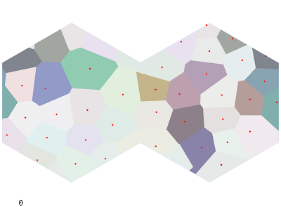
To approximate an irregular but blue-noised grid, I'll grab a Poisson Disk Sample from all points on the map. This is a pretty useful algorithm to know, so it's a good chance to rewrite it to be a bit more efficient. After generating the points, tectonic plates are generated as a Voronoi map with the Poisson Disks as the centers (the shapes it generates are too uniform, so I'll revisit that later). A Poisson radius of 100 hexes yields 36 centers and the following map. Oceanic plates (approximately % of the total area, close to Earth) are shown in a lighter shade.
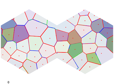
Each plate is assigned a random Euler pole and angular rate of rotation. I can use this to find the strength of collision at each boundary. I'm not super satisfied with the equations I'm using but they can always be modified.
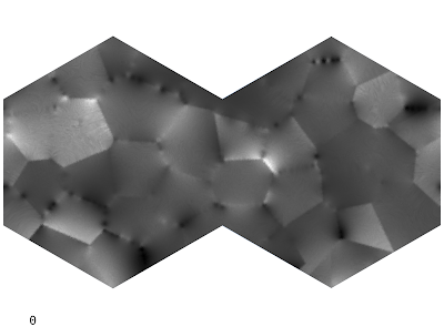
Next, the rate of tectonic uplift for a given hex is determined by each fault's effect on that hex, with a bonus for continental plates (which are lighter and tend to "float"). High uplift values will generate mountains and island chains.
In the past I've played around with various combinations of Perlin noise, domain warping, and other forms of distortion applied to the uplift map to get interesting topographies. The final topography is heavily dependent on the uplift value: the droplet model algorithm gives interesting local topography but is ultimately overpowered by the underlying uplift. So it's important to get it mostly right to begin with. That being said, I find it important not to get too caught up in fine details when there is underlying code to fix. And there is a lot of code to fix and refactor.
To get a rough idea of the kinds of terrain this will generate, we can mock up the elevation values from uplift (essentially scaling from 0 to our max height 25599) and apply a sea height of whatever makes the land percentage 29%. I changed the continents slightly from the plate image above.
Note how straight the lines are, something that will need to be fixed.
The elevation generator is quite slow (particularly given the size of the map), and so it may be a while before I have this round of kinks worked through. My basic algorithm is a droplet model which erodes land based on the tectonic uplift, water erosion, sediment deposition, and coastal erosion. In the past I have used the Wei-Zhou-Dong algorithm for depression filling (which makes all rivers flow to the sea), but I am not terribly pleased with it this time around. We'll see.
Safe to assume you'll be using this info to place mineral deposits?
ReplyDeleteMore or less. What I did last time was use combinations of the uplift values and terrain, etc, to make deposits more likely in certain areas.
DeleteIt would certainly be possible to use sediment deposition to track things like gold deposits and other minerals. I'll look into that when I come to it. I plan to spend a few weeks massaging the algorithms to produce more believable results - the straight lines yield straight coasts. Not very realistic.
That definitely sounds too much like real work - which dungeons should we buy the exploration licences near? :)
ReplyDeleteI've noticed with some regret that I read a good deal of doctoral dissertations on terrain generation, etc, with about the same level of detail as this blog.
Delete